

Getting Started
There are many things that need to be done when building a community from scratch. The first order of business of course is acquiring the land so you can build homes, businesses, churches and schools. When Joseph Goodrich, Henry Crandall and James Pierce arrived they were not the first white men here. Earlier in the year Mr. Peter McEwen came and acquired land in section 27 and 36. There were the Walker Brothers as well and George Ogden and a few others.
But, Joseph had a bigger plan than simply staking a claim and farming he wanted to build a community and he wasn’t afraid of hard work. He left his Uncles home with an ax and a dream at the age of 19, this time he had friends, supplies and a dream.
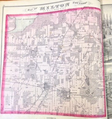
Platt Map courtesy of New Combination Atlas of 1873
and the Hedberg Library
Joseph claimed land in sections 26 and 27 and Mr. Crandall, after taking out a claim in section 28 one mile to the west, went back east for his family.
Being far from an established area there were no roads and Mr. Goodrich wanted to be sure that he was in just the right spot when they were built. So he drew an “air map” of where he thought the best routes would be from Madison, which was chosen the state Capitol in 1836, to Chicago a small town to the south with growth possibility. And from Fort Atkinson; eight miles north. To Janesville, five miles to the south. Neither of which was an established community at that time but he knew roads would be built and he wanted to be at that crossing point!
After planning where he thought the road placement would eventually be, Joseph built his family a home and dry goods store then left his assistant Mr. Pierce in charge and returned east for his family in September of 1838. It would be an interesting trip.
